|
||||||||||||
|
|
|
Ocean Dead Zones
"Dead zone" is a more common term for hypoxia, which refers to a reduced level of oxygen in the water. "Dead zones" are areas where the bottom water (the water at the sea floor) is anoxic — meaning that it has very low (or completely zero) concentrations of dissolved oxygen. These dead zones are occurring in many areas along the coasts of major continents, and they are spreading over larger areas of the sea floor. Because very few organisms can tolerate the lack of oxygen in these areas, they can destroy the habitat in which numerous organisms make their home. The cause of anoxic bottom
waters is fairly simple: the organic matter produced by phytoplankton at
the surface of the ocean (in the euphotic zone) sinks to the bottom (the
benthic zone), where it is subject to breakdown by the action of bacteria,
a process known as bacterial respiration. The problem is, while
phytoplankton use carbon dioxide and produce oxygen during photosynthesis,
bacteria use oxygen and give off carbon dioxide during respiration. The
oxygen used by bacteria is the oxygen dissolved in the water, and that’s
the same oxygen that all of the other oxygen-respiring animals on the
bottom (crabs, clams, shrimp, and a host of mud-loving creatures) and
swimming in the water (zooplankton, fish) require for life to continue.
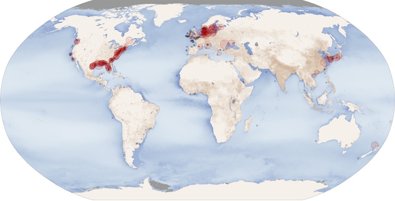
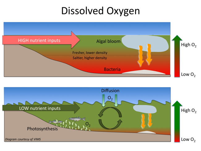
The size and number of marine dead zones—areas where the deep water is so low in dissolved oxygen that sea creatures can’t survive—have grown explosively in the past half-century. Red circles on this map show the location and size of many of our planet’s dead zones. Black dots show where dead zones have been observed, but their size is unknown. It’s no coincidence that dead zones occur downriver of places where human population density is high (darkest brown). Some of the fertilizer we apply to crops is washed into streams and rivers. Fertilizer-laden runoff triggers explosive planktonic algae growth in coastal areas. The algae die and rain down into deep waters, where their remains are like fertilizer for microbes. The microbes decompose the organic matter, using up the oxygen. Mass killing of fish and other sea life often results. Hypoxic zones can occur naturally, but scientists are concerned about the areas created or enhanced by human activity. There are many physical, chemical, and biological factors that combine to create dead zones, but nutrient pollution is the primary cause of those zones created by humans. Excess nutrients that run off land or are piped as wastewater into rivers and coasts can stimulate an overgrowth of algae, which then sinks and decomposes in the water. The decomposition process consumes oxygen and depletes the supply available to healthy marine life. Dead zones occur worldwide. The second largest dead zone in the world is located in the U.S., in the northern Gulf of Mexico. Dead Zone Formation
Large amounts of dead phytoplankton and zoo- plankton waste then accumulate on the bottom of the seabed. The decomposition of this matter depletes the oxygen in the area faster than it can be replaced. This leads to large hypoxic areas called Dead Zones. Hypoxia also
can kill marine organisms that cannot escape the low-oxygen water,
affecting commercial harvests and the health of affected ecosystems.
New research by the World Resources Institute (WRI) and the Virginia Institute of Marine Science (VIMS) identifies more than 530 low-oxygen “dead zones” and an additional 228 sites worldwide exhibiting signs of marine “eutrophication.” Eutrophication occurs when water bodies are over-fertilized by nutrients that are washed into surface waters from farms and urban areas. The 530 areas and 228 sites together encompass more than 95,000 square miles, about the size of New Zealand. The largest dead zone in the United States, at the mouth of the Mississippi, covers more than 8,500 square miles, roughly the size of New Jersey. A large dead zone also underlies much of the main-stem of Chesapeake Bay, occupying about 40 percent of the Bay’s area and up to five percent of its volume each summer. Map by Robert Simmon & Jesse Allen; based on data from Robert Diaz, Virginia Institute of Marine Science (dead zones); the GSFC Ocean Color team (particulate organic carbon); and the Socioeconomic Data and Applications Center (SEDAC) (population density).
Credit: NOAA, NASA,WRI, VIMS |


